

Geoheritage assessment in the Perşani Mountain Volcanic Field and volcanological studies of the Racoş area (South-eastern Carpathians, Romania)
Soós Ildikó, II. year PhD-student
Doctoral School of Environmental Sciences - Environmental Geosciences
Supervisor: Szabolcs Harangi, DSc, Professor, Director of the Institute of Geography and Earth Sciences, Eötvös University Budapest (ELTE)
Over the past two decades, geological heritage protection has received increasing attention. This is also evidenced by the fact that there are now 161 UNESCO Global Geoparks worldwide in 44 countries, 3 of which are in the Carpathian-Pannonian region (the Bakony-Balaton Geopark in Hungary, the Novohrad-Nógrád Geopark across the Hungarian-Slovak border and the Haţeg Country Dinosaurs Geopark in Romania). One of the main goals of my research is to help with my scientific results the geological background material of the aspiring Carpaterra Geopark. Volcanological research also contributes to the understanding of the formation of the area, thereby increasing its scientific and touristic value.
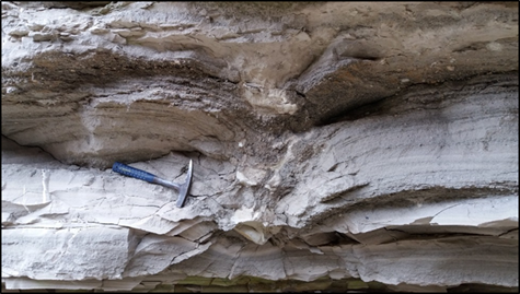
Fig. 1 Imapct sag with volcanic bombs in the pyroclastic succession from Mateiaş
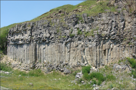
Fig. 2 The basalt columns from Racoş
In the southern part of the Eastern Carpathians, the alkaline-basalt volcanic area of the Persani Mountains was formed 1.2-0.6 million years ago. The monogenetic (different volcanic edifices formed during a single eruptive event lasting weeks or decades) volcanic field covering only 172 km 2 (Seghedi et al., 2016) is one of the smallest and youngest in the Carpathian-Pannonian region (Harangi et al. 2015). The volcanic activity took place in five short phases while creating 21 monogenetic volcanic centers. Mostly eroded volcanic formations from the explosive volcanic eruption can be recognized in the area. These include maar/tuff ring phreatomagmatic pyroclastic sediments (Fig. 1), scoria cones formed by the Stromboli-type eruption (Fig. 3), and lava fields formed by effusive processes (Fig. 2) (Panaiotu et al., 2016, Seghedi et al., 2016).
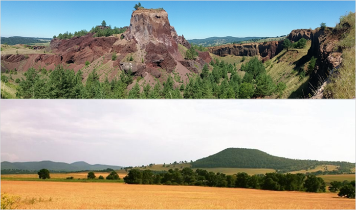
Fig. 3 On the upper picture, we can take a look inside the Heghes scoria cone. Thanks to quarrying, we can observe the reddish pyroclastic rocks and lava batches of the volcano. On the lower photo presents the Gruiu scoria cone with its regular conical shape.
After a thorough study of the literature as well as geological and topographic maps, we selected the best geosites (natural or manmade geological sites: it could be an outcrop, a quarry or even a cave, etc.) from a scientific, educational and geotouristic point of view. This was followed by a field survey where the selected geosites were identified. The next step was the assessment of the selected geosites with two of the most applied methods used by scientists. Vujicic et al. (2011) used the GAM (Geosite Assessment Model) method to assess the current state of geosites using different indicators for main and added values. Main values: scientific / educational (rarity, representativeness, scientific knowledge, level of interpretation), scenic / aesthetic (number of viewpoints, surface, surrounding landscape, environmental fitting of sites) and protection (current condition, protection level, vulnerability, suitable number of visitors). Added values: functional (accessibility, additional natural and anthropogenic values, vicinity of emissive centers, important road network, other facilities) and tourism (promotion, number of guided tours, vicinity of visitor centers, interpretative panels, annual number of visitors, geotourism infrastructure, tour guide services, accommodation and dining options). Brilha, J. (2016) used similar indicators to the previous method for the assessment, except that it also took into account the degradation risk. To reduce subjectivity, the indicators were calculated with a different weighting factor. The assessment of geosites helps to evaluate the current conditions of the selected geosites. It highlights the strengths or weaknesses of it, thus helping the work of the local administrators on territorial development planning and contributes to the documentation and inventory of the planned geopark. It is recommended that these surveys be repeated from time to time to monitor the development or potential vulnerability of the area.
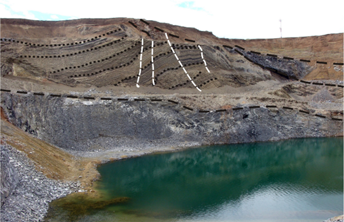
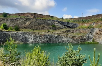
Fig. 4 The Brazi quarry. Above the lake level, which is mainly rainwater, is visible the intrusive lava body (basalt) (delimited by a black dashed line). Above this are located the alternating (lighter /darker) volcanic sediments (pyroclastic) (delimited by black dotted lines). This unites are crossed by a few faults (marked by white dashed line).
Because such monogenetic volcanic fields can be active for millions of years, sometimes with tens of thousands or hundreds of thousands of annual breaks, a better understanding of volcanic function is essential, especially as it is located in an active geodynamic environment. During this doctoral research, we pay the most attention to the formation of the Racos volcanic area. During the volcanological fieldwork, we paid special attention to the documentation of the different deposition forms, primary and reworked stratigraphic series. This was complemented by grain size distribution, composition, and morphological studies of juvenile and accidental clasts, which were determined using a petrological and scanning electron microscope. By measuring the density of pyroclastic and characterizing their vesicularity (e.g., size, shape, density), we clarify the conditions and mechanism for the uplift and degassing of magma. This clarifies the changing conditions that took place in the vent during successive eruption phases. We investigated in detail the chemical composition of the pyroclasts and lava rocks (major and trace elements) in the Hegyes scoria cone near Racoş village and in the Brazi quarry (Fig. 4) and in the pyroclastic deposit near Mateiaş village. Based on a preliminary evaluation of the geochemical data, it appears that there is no large geochemical difference between the investigated eruptive products. However, some trace element variability can be observed, which may suggest that the magmas feeding the phreatomagmatic eruptions were formed by a slightly higher rate of melting. The Hegyes scoria cone and the lava rocks of the Brazi quarry were created by a homogeneous composition of slightly differentiated magma uplift.
Refference
- Brilha, J. 2016. Inventory and quantitative assessment of geosites and geodiversity sites: a review. Geoheritage 8:116. DOI: 10.1007/s12371-014-0139-3
- Harangi, Sz., Jankovics, M.E., Sági, T., Kiss, B., Lukács, R., Soós, I. 2015. Origin and geodynamic relationships of the Late Miocene to Quaternary alkaline basalt volcanism in the Pannonian basin, eastern–central Europe. Int J Earth Sci 104(8):2007-2032
- Panaiotu C.G., Dimofte D., Necula C., Dumitru A., Seghedi I., Popa R-G. 2016: Revised paleosecular variation from Quaternary lava flows from the east Carpathians. Romania. Reports in Physics 68(1), 416–424.
- Seghedi, I., Popa, R-G., Panaiotu, C. G., Szakacs, A., Pecskai, Z. 2016. Short-lived eruptive episodes during the construction of a Na-alkalic basaltic field (Perşani Mountains, SE Transylvania, Romania). Bull Volc 78:69
- Vujičić, M. D., Vasiljević, D. A., Marković, S. B., Hose, T. A., Lukić, T., Hadzic, O., & Janicević, S. 2011. Preliminary geosite assessment model (GAM) and its application on Fruska Gora Mountain, potential geotourism destination of Serbia. Acta Geogr Slovenica, 51(2): 361–37.
Ildikó Soós