

Determining the development of the bend and exploring its causes in the section of the Rába river between Alsószölnök and Sárvár
Alexandra Pusztai-Eredics, II. year PhD-student
Doctoral School of Environmental Sciences - Environmental Geosciences
Supervisor: Zoltán Sámuel Kolláth
The Rába enters the territory of Hungary at Alsószölnök, the river from the border to Sárvár is mostly in its natural state, it often changes its course, meandering along the valley floor. The river flows from Sárvár in a regulated riverbed protected by flood protection embankments, all the way to the estuary of Győr.
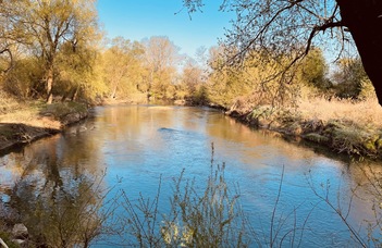
Rába offers a particularly good opportunity to study the spatial and temporal changes in the development of the meanders, as the development of its meanders is rapid, so significant changes in the shape of the meanders and the migration of the riverbed can be observed in a few decades. The section of the Rába between Alsószölnök and Sárvár can be called practically “pristine”, as so far only a few significant construction-regulatory interventions have taken place at the site, so it is suitable for studying the natural processes of meander development.
Lateral erosion is a fundamental process that controls the displacement of meandering rivers and, depending on its extent and intensity, can cause severe damage in agriculturally cultivated areas or along populated areas (Lawler et al. 1997, Das et al. 20 12, Hackney et al. al. 2015, Konsoer et al. 2017, Bertalan 2019). The horizontal bed pattern of partially regulated or completely unregulated meandering rivers can develop further at a significant rate (up to several meters / year) (Hooke 2008, Mirijovsky et al. 2015, Bertalan et al. 2016, Bertalan 2019). It can be observed that the main problem along the unregulated sections is caused by the intensive development of the bends.
Few researchers have dealt with the morphological conditions and the development of the bends of the Hungarian section of the Rába, moreover, their investigations mainly covered the regulated section between Sárvár and Győr, so no comprehensive river morphometric research has been carried out on.
In the course of the research, my aim is to explore the changes in the riverbed dynamics that took place in the Hungarian section of the Rába (especially the section between Alsószölnök and Sárvár), and to identify the sections most endangered by the recent meander development. I consider it important to present the negative and possible positive effects of the riverbed change processes in the Hungarian section of the Rába, taking into account tectonic, geomorphological and hydrological aspects. In the course of my research, I am looking for answers to the following questions:
- How does the bed change over time, and what factors influence the process of change? (Geology, tectonics, geodynamics, maximum water flow)
- Can the former river path provide useful information on recent geological, - primarily tectonic -, developments in the area?
- Is there a correlation between substrate morphology and surface phenomena?
- How did these change the shape of the water network during the research period?
With the help of topographic maps and descriptions of water management planning surveys, aerial photographs and orthophotos made during the last 150-200 years, we can get an idea of the direction and pace of the riverbed development. Nowadays, the toolbox of geoinformatics, supplemented by remote sensing methods, enables fast and accurate data collection and systematization, with which the peculiarities of horizontal riverbed development can be effectively explored.
Map raw materials from different sources with different formats and different projections had to be integrated into the developed geoinformatics system with the greatest possible accuracy. The maps were converted to the same projection system (EOV) using QGIS software in order to analyze the bed change uniformly. Subsequently, the timing of the map sections produced during a mapping campaign, which could be up to 10 years apart, had to be determined for each sheet of all data sources.
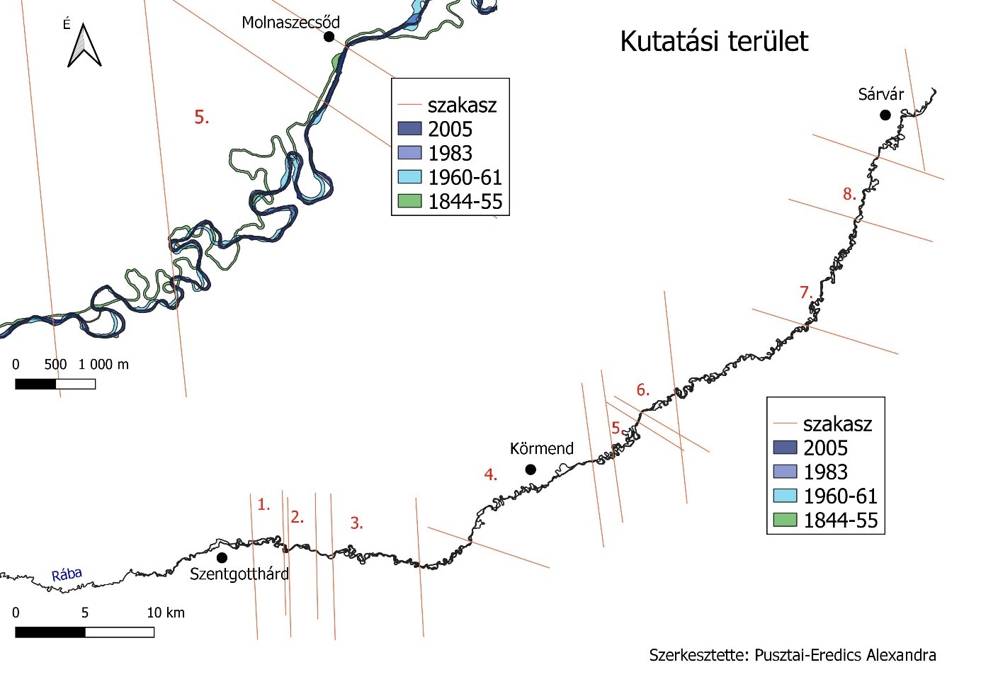
Fig. 1: Movement of the riverbed on the valley floor as a function of time
The bed changes are shown in Fig. 1. The changes in the running of the river shoreline are well illustrated by the presentation of the running line mapped at several times. By classifying the distances, we get the degree of displacement. However, instead of a qualitative representation, the results obtained must be quantified and then the speed of displacement is obtained. Based on the further analysis of the map, the sections where the development of the meanders is the most intensive can be selected within the examined river section. The intensity can also be plotted on a diagram (Fig. 2).
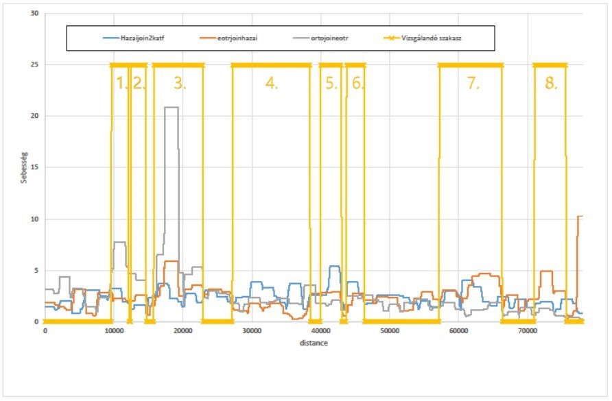
Fig. 2: The rate of bed movement at different times in the selected sections
The meandering of rivers, riverbed erosion and migration can also be influenced by tectonism. In the case of meandering watercourses in the lowlands, where the channeling is small (3-31 cm / km), vertical tectonic movements along the riverbed can change the morphology of the riverbed, they can have a significant effect on river systems (Watson et al. 1983; Smith et al. 1997, Tímár 2005, Blanka 2009, Blanka 2010). They can change the shape of the water network in the river basin district, cause the riverbed to fill up or cut, change the riverbed pattern or meandering, but it can also cause riverbed relocation and riverbed diversion. Therefore, rivers are also suitable for detecting displacements that have occurred recently or are recent, but show extremely slow motion and cannot be detected in any other direct way (Keller-Pinter 2002; Miall 1996; Blanka 2009). Thus, changes in river meandering may reflect the location of fault lines, folds, and differences in the amount of vertical displacement in tectonically active areas.
Exploration of the state of the meandering river can be realized by examining the morphological parameters. One such parameter is meandering, which is the quotient of the distance between the two points of the river and the overhead line. The higher the number we get, the better it turns.
This calculation is performed by the GIS software for each point. The value for the riverside points was plotted (Fig. 3, red line). If the test is performed with several window sizes (i.e. with several predefined distances), a spectrum is obtained. Where the spectrum turns red, it is worth investigating further, looking for a fault line or geological change. The sites marked with gray bars in Fig. 4 are Cenozoic fault lines, it is not yet known which one is neotectonic and which is active.
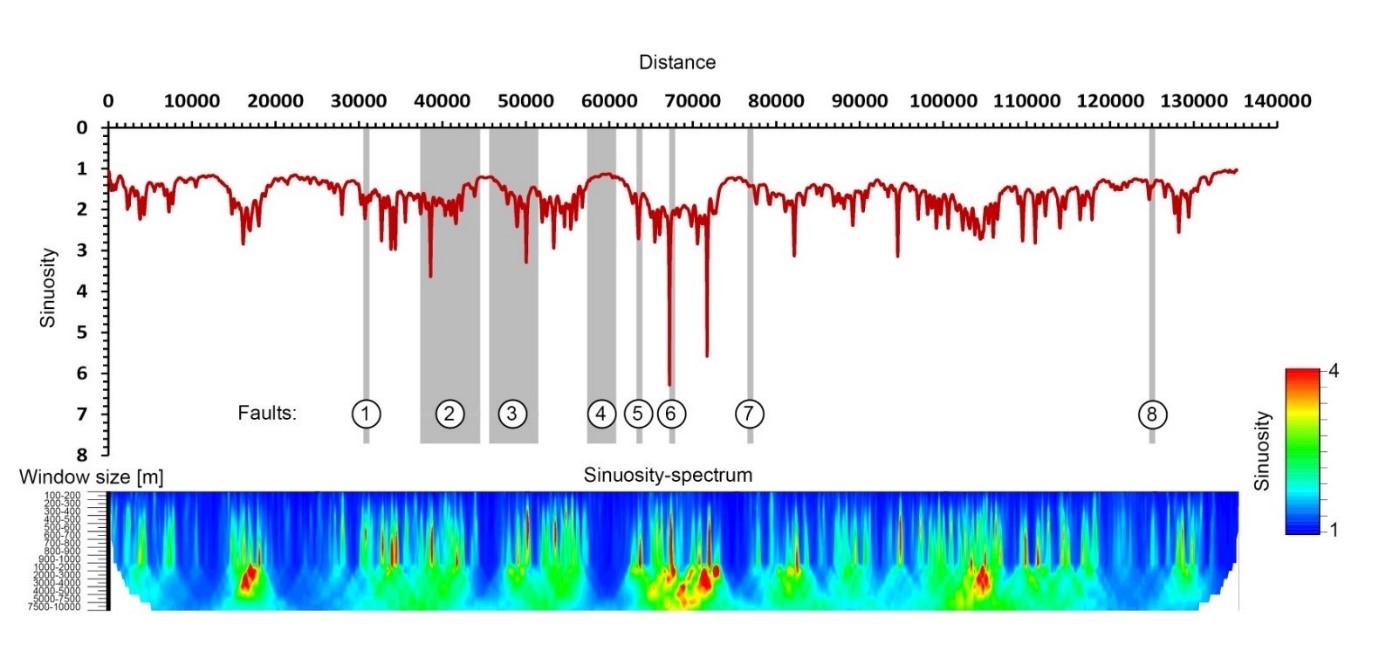
Fig. 3: Rába sinuosity change
The development of meanders, the migration of the riverbed and the consequent destruction of the coastal landscape raise primarily issues of personal safety and the national economy. With the migration of the riverbed, populated areas, agricultural lands may be endangered, and the risk of floods may increase. A further challenge is the permanent subsidence of small waters, as water abstraction (drinking water, irrigation water and cooling water) is facing increasing difficulties. Examining the migration of the riverbed is important precisely in order to be able to model, predict and eliminate these damages.
REFERENCES
Bertalan, L., Szabó, G., Szabó, S., 2016. Soil degradation induced by lateral erosion of a non- regulated alluvial river (Sajó River, Hungary), in: Zapletalová, J.; Kirchner, K. (Ed.), Aktuální Environmentálni Hrozby a Jejich Impakt v Krajiné (Current Environmental Threats and Their Impact in the Landscape Brno): Sbornik Abstraktu Z Mezinárodniho Workshopu. Ústav geoniky AV CR, pp. 8-9.
Bertalan L., 2019. A horizontális mederdinamikában bekövetkezett változások geomorfológiai, hidrológiai és ökológiai összefüggései a Sajó hazai szakaszán, Egyetemi doktori (PhD) disszertáció, 173p.
Blanka V., 2009. Jelenkori tektonizmus hatása a Hernád kanyarulatfejlődésére.
Blanka, V. 2010. Kanyarulatfejlődés dinamikájának vizsgálata természeti és antropogén hatások tükrében. Doktori (PhD) értekezés. Szegedi Tudományegyetem, 144p.
Das, A.K., Sah, R.K., Hazarika, N., 2012. Bankline change and the facets of riverine hazards in the floodplain of Subansiri-Ranganadi Doab, Brahmaputra Valley, India. Nat. Hazards 64, 1015- 1028. DOI:10.1007/s11069-012-0283-5
Hackney, C., Best, J., Leyland, J., Darby, S.E., Parsons, D., Aalto, R., Nicholas, A., 2015. Modulation of outer bank erosion by slump blocks: Disentangiing the protective and destructive role of failed material on the three-dimensional flow structure. Geophys. Res. Lett. 42, 10,663-10,670. DOI:10.1002/2015GL066481
Hooke, J.M., 2008. Temporal variations in fluvial processes on an active meandering river over a 20-year period. Geomorphology l 00, 3-13. Dül: l 0.1016/j.geomorph.2007.04.034
Keller, E. A., Pintér, N., 2002. Active Tectonics: Earthquakes and Landscape. — Second Edition. Prentice-Hall: Upper Saddle River
Konsoer, K., Rhoads, B., Best, J., Langendoen, E., Ursic, M., Abad, J., Garcia, M., 2017. Length scales and statistical characteristics of outer bank roughness for large elongate meander bends: The influence of bank material properties, floodplain vegetation and flow inundation. Earth Surf. Process. Landforms 42, 2024-2037. DOI:10.1002/esp.4169
Lawler, D.M., Thorne, C.R., Hooke J.M., 1997. Bank erosion and instability. In. Throne, C.R. et al (szerk.) Applied Fluvial Geomorphology for River Engineering and Management. Wiley, Chichester. 137-173.
Miall, A.D. 1996: The geology of fluvial deposits. Springer, Berlin. 522.
Mifijovsky, J., Sulc Michalková, M., Petyniak, O., Mácka, Z., Trizna, M., 2015. Spatial- temporal evolution of the unique preserved meandering system in central Europe- The Morava River near Litovel. Catena 127, 300-311 DOI: l 0.1 O 16/j .catena.20 14.12.006
Smith N.D. - McCarthy T.S. - Ellery W.N. - Merry C.L. - Rüther H., 1997. Avulsion and artastomosis in the panhandle region of the Okavango Fan, Botswana. Geomorphology 20, 49-65.
Tímár G., 2003. Controls on simuosity changes: a case study of the Tisza River, the Great Hungárián Plain. Quaternary Science Review 22, 2199-2207.
Watson C.C. - Schumm S.A. - Harvey M.D., 1983. Neotectonic effects on river pattern. In: Elliott CM. (ed): River Meandering. Proceedings of the Conference on Rivers, 55-66.
Pusztai-Eredics Alexandra